Rongai Route
The Rongai Route approaches Kilimanjaro from the north, just south of the Kenyan border. It is one of the least traveled routes on the mountain, offering a quieter experience especially in the early days. Descent is via the Marangu Route on the south side, so you see the mountain from different viewpoints.
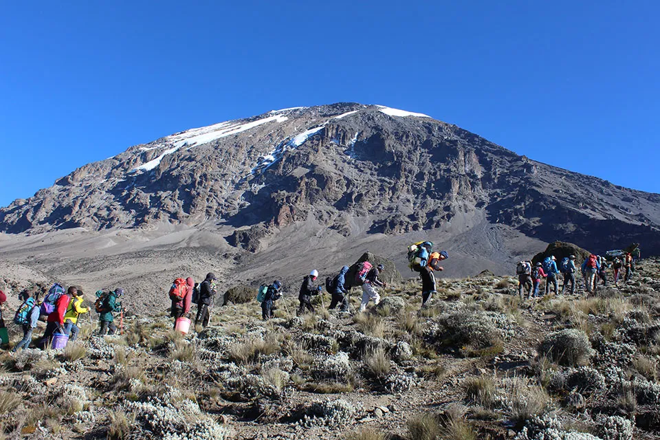
6 Days Rongai Route
The drive to the trailhead takes about 2–3 hours from Moshi through villages and coffee plantations, with a stop to register climbing permits at Marangu. The route can also be accessed from Amboseli National Park in Kenya (allow about 2 hours including the border crossing; copies of passports are needed in advance).
What to Expect on the Trek
Quiet northern start
Rongai is one of the least used routes, so the first few days are often quieter than the southern approaches.
Views of Kenya
Early camps offer extensive views over the Kenyan plains, and the approach itself is scenic.
Descent via Marangu
You finish on the classic Marangu Route, seeing the mountain from the south side as well.
Steady ascent
The trail climbs consistently but generally gently through forest, moorland and alpine desert.
Rongai 6 Days Quick Facts
| Route type | Camping route approaching from the north |
|---|---|
| Duration | 6 days on the mountain plus arrival day |
| Start | Nale Moru / Rongai Gate (north side) |
| Finish | Marangu Gate |
| Summit | Uhuru Peak, 5,895 m (19,341 ft) |
| Accommodation | Private four-season mountain tents |
| Main camps | Simba → Second Cave → Third Cave → Kibo → Horombo |
| Technical skills | None required |
Explore the Detailed Itinerary
Day 0Arrival in Tanzania
Arrive at Kilimanjaro International Airport (JRO), where you will meet a Kilimanjaro Joyful Adventures representative and transfer to your hotel. The hotel provides all the essentials for a comfortable stay, and your guide will brief you and check your gear.
Day 1Hotel to Simba Camp
Drive to the village of Nale Moru (about 2 hours including a stop for permits at Marangu). After signing in and preparing the porters, you begin the hike on a wide path through fields of maize and potatoes before entering pine forest. The track climbs consistently but gently. The first camp is at the edge of the moorland zone with extensive views over the Kenyan plains.
Day 2Simba Camp to Second Cave
The morning hike is a steady ascent up to the Second Cave with superb views of Kibo and the Eastern ice fields on the crater rim.
Day 3Second Cave to Third Cave
Today we continue from the Second Cave to the Third Cave, gaining more altitude as the landscape becomes more open and alpine.
Day 4Third Cave to Kibo Hut
Hike to Kibo Hut at the bottom of the Kibo crater wall. The remainder of the day is spent resting in preparation for the final ascent and a very early start.
Day 5Kibo Hut to Uhuru Peak, then down to Horombo Hut
Very early (midnight to 2 am) you begin the climb on steep scree or snow to Gilman’s Point on the crater rim (about 5,700 m). From there you continue to Uhuru Peak – the highest point in Africa. After celebrating you descend, stopping for lunch and a rest at Kibo before continuing to Horombo Hut. This is the most demanding day; go slowly (“pole pole”) and keep a positive attitude.
Day 6Horombo Hut to Marangu Gate to Hotel
After breakfast a steady descent takes you through moorland to Mandara Hut and then through lush forest to the National Park gate at Marangu. At lower elevations it can be wet and muddy. Your vehicle meets you at Marangu Gate and drives you back to your hotel in Moshi (about 1 hour).
Elevations, distances and times are approximate and can change with weather and group pace.
Camps and Altitude at a Glance
| Night | Camp | Approx. altitude |
|---|---|---|
| 1 | Simba Camp | 2,650 m / 8,700 ft |
| 2 | Second Cave | 3,450 m / 11,300 ft |
| 3 | Third Cave | 3,880 m / 12,700 ft |
| 4 | Kibo Hut | 4,750 m / 15,600 ft |
| 5 | Horombo Hut (after the summit) | 3,700 m / 12,200 ft |
Price Includes & Excludes
Includes
- Quality, waterproof, four-season private mountain sleeping tents
- Professional, experienced mountain guides
- All park fees
- Airport transfers
- Rescue fees
- All meals while on the mountain
- Guides, porters and cook salaries and park fees
- Quality mess tents with table and chairs
- Large portions of fresh, healthy, nutritious food
- Clean, purified drinking water
- Oximeter
- Medical kit
- Emergency oxygen
- Crisis management and safety procedures
- Fair and ethical treatment of porters
- 2 nights’ accommodation in Moshi/Arusha before and after the climb
Excludes
- Flights
- Alcoholic and soft drinks
- Visa fees
- Tips and personal spending money for souvenirs, etc.
- Travel insurance
Read our booking terms and check the Tanzania visa guide before you travel.
How to Prepare for the Rongai Route
Train for steady days
Days are generally moderate in length. Practise hiking with a daypack and break in your boots well before travel.
Pack for every climate
You move from forest and moorland to alpine desert and arctic summit conditions. See our equipment and gear list.
Go slowly
Drink plenty of water, walk at a steady “pole pole” pace and tell your guide about any symptoms. Read about safety on Kilimanjaro.
Choose your season
The dry seasons (January–mid-March and June–October) usually give the best conditions. See the best time to trek.
Rongai 6 Days: Frequently Asked Questions
Is the Rongai route less crowded?
Yes. Rongai starts on the northern side of Kilimanjaro near the Kenyan border and is one of the least traveled routes, especially in the early days.
Where does the Rongai route start?
The trailhead is near the village of Nale Moru on the north side of the mountain. The drive from Moshi takes about 2–3 hours (including permit registration at Marangu).
Can I start Rongai from Kenya?
Yes. The route can also be accessed from Amboseli National Park in Kenya (allow about 2 hours including the border crossing). Copies of passports are needed ahead of time.
How do we descend on the Rongai route?
Descent is via the Marangu Route on the south side of the mountain, so you see Kilimanjaro from different viewpoints.
Do we sleep in tents or huts?
On the 6-day Rongai itinerary you sleep in quality four-season private mountain tents (camping version).
What is not included in the price?
Flights, alcoholic and soft drinks, visa fees, tips and personal spending money for souvenirs, and travel insurance are not included.